
Sunday August 24th 2016
TTC information host, why cut funds to public service that understands it needs to go this far.

Sunday August 24th 2016
Metrolinx Davenport Diamond Meeting: 2016-04-27
Published on Apr 28, 2016
A mostly complete video of Metrolinx’s meeting regarding the Davenport Diamond Grade Separation on April 27 2016, at St. Sebastien Catholic School
by Vic Gedris.
A still from the blog authors filming this weekend, where the crew again informs me to look at the camera.
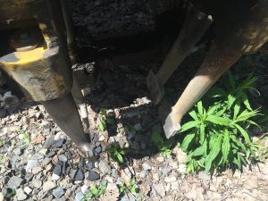
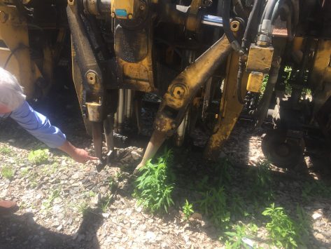
Maintaining a railroads steel rail, sleepers and ballest contributes greatly to the safety of a railroads running track or yard storage track.
… some text from a rail tamper machine manufacturer, that makes a tamper commonly used in Ontario.
When a train travels over a track, it generates enormous forces. The entire track consisting of rails, sleepers and ballast is an elastic system that deforms and returns to its original position.
Over the long term this high stress results in deterioration of the track geometry. This can lead to anomalies, which means that the ideal geometry of the track is no longer assured and in these areas it becomes necessary to impose temporary speed restrictions.
To avoid such a situation, tracks should be maintained at regular intervals – this includes levelling, lifting, lining and tamping. This ensures that the ideal geometry of the track is restored.

Plasser American machines/equipment with a tamping machine, diaagram
The City of Toronto’s City Planning Division and the to link downtown with the Bloor-Danforth Subway east of the Don River.
Report on the development of Toronto’s transit network plan
A staff report on the development of Toronto’s transit network plan is being presented to the City’s Execuitve Committee on March 9. This report recommends that the City
Approve Pape to Downtown via Queen/Richmond as the preferred corridor for the Relief Line project
For more information about the corridor analysis and to provide your feedback, please visit the project webpage.
City staff report are the Continue reading link
Click on image for full size view.
all text the group.
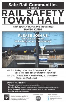
Since March 2014, Safe Rail Communities has been advocating for greater safeguards and transparency with respect to the transportation by rail of dangerous goods, particularly volatile crude oil.
Despite the tragic loss of 47 lives during the July 6th, 2013 rail disaster in Lac-Mégantic, Canadians have witnessed two more fiery crude oil derailments in 2015. These derailments occurred within three weeks of each other, and both just outside the same town of Gogoma in northern Ontario. Each of these explosive derailments, as well as those of 2014, demonstrate that Minister Raitt’s response to the situation has been largely ineffective.
Please join us for an informative meeting on this important issue with special guest and moderator, Naomi Klein, and a panel of experts:
Invited guests include Minister Raitt, NDP Transport Critic Hoang Mai, and Liberal Transport Critic David McGuinty. Also invited are all GTA MPs with rail lines in their riding, Mayor John Tory, and all Toronto City Councillors.
Please share this event on Facebook and Twitter
We look forward to seeing you there! Doors open at 6:30pm.
Patricia & Helen
Safe Rail Communities
WHEN: Friday, June 12 at 7:00 pm-9:30 pm
Doors will open at 6:30pm for the Town Hall
WHERE: Central YMCA Auditorium, 20 Grosvenor
(Yonge and Wellesley)
All text aljazeera.com
click here to view their video
London’s underground rail system has a long and storied history of being used for tasks other than transporting the city’s millions of residents.
With passenger numbers dwindling, Down Street Station closed more than 80 years ago, only to become the corridors of power during the second world war.
Twenty metres below ground and safe from German air force bombs, Prime Minister Winston Churchill, along with 25 administrative staff and soldiers, used the station to meet his war cabinet and send messages.
In 2015 there is no longer a need for such wartime preparations, but there are plans to once again revive London’s so-called ghost stations with restaurants, art galleries and even a cinema.
Speaking on the plans for Down Street Station, Graeme Craig, commercial director of Transport for London, told Al Jazeera: ”This is a unique space within London. It’s a space not used by passengers since May 1932. … It’s in the heart of Mayfair – it’s unique location, history, and space.”
Heading south from under the Keele St. Canadian Pacific Railway subway just north of Vine Ave, Sunday the 23rd of Feb. a hole lot of bumper to bumper traffic. From the experience of this the residents of the area will have to adapt themselves for a considerable new time lag in transverse travel time along the maim NS Keel St travel route as the new Stockyard Mall opens the bulk of the malls stores
March 3rd the stockyards Second cup opens.


The blog has highlighted the very resonating parts…
From the media release here
….more than half Britain’s rail network will be electrified with electric trains accounting for three-quarters of all traffic.
Once electrification schemes including the Great Western and Midland main lines, Liverpool to Manchester and Preston, the Valley lines in south Wales and the ‘electric spine’ from Southampton docks to the West Midlands and Yorkshire are complete, more than half Britain’s rail network will be electrified with electric trains accounting for three-quarters of all traffic.
Simon Kirby, managing director of Network Rail’s infrastructure projects division, said: “Our work to electrify two thousand track miles represents the biggest programme of rail electrification in a generation and will provide faster, quieter and more reliable journeys for millions of passengers every week while cutting the cost of the railway.
“Thanks to a firm commitment from government to invest in electrification schemes across the country, we are transforming the railway and providing Britain with a sustainable, world-class transport system that is fit for the future. To deliver this work in the safest and most efficient way possible, we need to make the most of the huge potential within our supply chain.”
Six geographic framework contracts have been awarded, with each having a defined workbank of schemes to be delivered. This approach has been endorsed by the supply chain and industry groups such as the Railway Industry Association.
Simon Kirby continued: “With billions of pounds set to be invested in electrification schemes over the next decade, and with many projects at different stages of development, it is absolutely vital that the supply market gets a clear, consistent message from Network Rail about what the company needs from its supply partners, where and when.
“The framework approach chosen by Network Rail gives suppliers a greater degree of certainty about the company’s pipeline of work and means suppliers can target investment so they have the right people with the right skills in the right parts of the country to deliver schemes which will improve our railway and boost economic growth.”
All text Go Transit,
What we are doing
• We are grading and installing track and signals between Lansdowne Avenue and Dupont Street to complete the expanded rail corridor for increased transit service.
• We are accessing the corridor at two locations to finish construction by the end of this year. The first is already in use at Dundas Street West and Brad Street. The second access will be at 158 Sterling Road where we will also store new track materials.
• Trucks will cross the West Toronto Railpath to enter and exit the rail corridor at the Sterling Road location.
How this will affect you
• We will begin to use the 158 Sterling Road access/storage on early February until the end of 2014.
• Railpath users will have the right-of-way over construction vehicles. A traffic control person will be positioned at the access point during construction hours. Appropriate signage will be in place along the path advising users of the condition ahead. Signage will also be placed along the access road reminding drivers to stop and yield to railpath users.
• Regular work hours are Monday to Friday 7 a.m. to 7p.m., Saturdays 9 a.m. to 7 p.m. There may be occasional work on Sundays from 9:00 a.m. to 5:00 p.m.
• We expect an average of 8 to 10 trucks per hour to use this access on a daily basis.
• All trucks will travel along Sterling Road from Dundas Street West to access the construction site.
• We will regularly clean the roads our trucks will be using, including the West Toronto Railpath.
Toronto as a city – the elected members and the public talk, talk, talk about transit, then agree somewhat and start, then cancel mid construction, well you know the story.
However what if we just jumped ahead to the next obvious transport method, that is what happened when Stephenson’s Rocket came along.
We did it before! People were excited in 1977 to view inside the TTC Wychwood Barns to view the exciting and then new fleet of street-cars which ride our street rails.
below is a link to Elon Musk document – released days ago – of his HYPERLOOP rail transport idea, the tech is amazing as well as the practical thoughts to get it done.
…a great read, for transit brilliance, OH, and if you are into start-up pitches also educative.

Click image to visit Space X web site
If we are to make a massive investment in a new transportation system, then the return should by rights be equally massive. Compared to the alternatives, it should ideally be:
• Safer
• Faster
• Lower cost
• More convenient
• Immune to weather
• Sustainably self-powering
• Resistant to Earthquakes
• Not disruptive to those along the route
Is there truly a new mode of transport – a fifth mode after planes, trains, cars and boats – that meets those criteria and is practical to implement? Many ideas for a system with most of those properties have been proposed and should be acknowledged, reaching as far back as Robert Goddard’s to proposals in recent decades by the Rand Corporation and ET3.
Unfortunately, none of these have panned out. As things stand today, there is not even a short distance demonstration system operating in test pilot mode anywhere in the world, let alone something that is robust enough for public transit. They all possess, it would seem, one or more fatal flaws that prevent them from coming to fruition.
The links again

Picture credit – woodleywonderworks click image to visit his Flickr site
A simple post of a article hat highlights the similar road issues Toronto has and possible methods to pay for the repair and replacement of our crumbing roads.
…all excerpts below from the article, much more in the complete article.
The sheer size of those needs, combined with a diminishing capacity to pay for it with public money, may speed up private sector involvement in the province unlike anything seen before in Canada.
“We believe this year is going to be a game-changer,” said Vincent Joli-Coeur, vice-chairman of National Bank Financial, which has participated in several major infrastructure financings including the bond sale for Montreal’s $2.6-billion CHUM hospital redevelopment. “In the past, we used to be able to spend years discussing new ways of [project procurement and funding]. Now it’s imminent.”
The only question is just how creative Quebec will get with its funding solutions. Mr. Joli-Coeur believes necessity will push the province to bring in private investors such as pension plans to fund things that were previously unthinkable, including public transit development.
“Public transit, in our view as financiers, is the next frontier,” he said. “It’s never been financed in the private sector in Canada.”
Ontario, too, wants to undertake a massive public transit expansion in the Toronto-Hamilton area. To pay for it, a government-appointed advisory panel in December recommended raising existing gasoline taxes as much as 10¢ per litre to 24.7¢ and weighing an increase in the province’s harmonized sales tax. The panel also discussed increasing corporate taxes and using a mechanism known as “land value capture,” which would collect part of the increase in the value of land located near new transit lines.
Most of those solutions wouldn’t fly in Quebec without drawing significant public protest. Quebec motorists already pay 22.2¢ per-litre in gas tax, and with salaries barely budging year-over-year, people won’t want to pay much more. Meanwhile, the government already increased its provincial sales tax in both 2011 and 2012.
“Most of the revenue tools [being contemplated] by Ontario to finance public transit will have a hard time being sold in Quebec,” Mr. Joli-Coeur said. “The conventional ways of doing things … has to change.”
Take Hong Kong. The city’s Mass Transit Railway Corp. (MTR) carries five million passengers every weekday over 218 kilometres of rail lines, offering its customers things other transit systems only dream of: 3-G and free wi-fi telecommunications service for passengers, public computers, library book drops, elevators down to track-level, and first-class cars on longer routes. It’s one of the few transit agencies anywhere that actually makes money.
“If the infrastructure is not self-sustaining, it cannot rely on public funding always being there,” MTR chief executive Jay Walder told an audience last year at Harvard University. “At some point politics simply diverts the money elsewhere.”
The thinking in all of these mechanisms is that expanding transit boosts the value of property near the transit lines, and that those who benefit from that should contribute to the cost. The tricky part, however, lies in how to go about it. Tax businesses too much and you risk scaring them away. Ask too little and you don’t generate enough money to fund your projects.
“The development community are not adverse to participating in the cost of certain transportation investments because they know that they are the beneficiary,” said Blake Hutcheson, chief executive of Oxford Properties, the real estate investment arm of pension fund manager OMERS. “The difficulty is how do you get at that, how do you quantify it?”
Oxford Properties is involved in a separate real-estate/transit development project in Manhattan called Hudson Yards.
…extracted from a Toronto Star interview
Wynne, however, did highlight what the city of Los Angeles did in 2008 with “a dedicated, 30-year, 0.5-per cent regional sales tax, which is expected to pour approximately $40 billion into their transit expansion effort.”
“They recognized the problem, they came up with a plan that was right for them and they took action,” the premier said, noting potential solutions may also be found in Europe.
She also pointed to Stockholm, Sweden, where in 2006 officials began charging congestion tolls based on the time of day in a six-month experiment.
“During that same period, they increased the availability of public transit. Six months later, the improvements to commuter travel times were even better than expected. There was a measurable, positive impact on Stockholm’s air quality and on the downtown economy,” she said.
“The trial also had a positive impact on traffic in the whole region, not just within the city limits. And Stockholm citizens overwhelmingly supported keeping the toll.”
When I started work on this history, my intention was straightforward: to create a comprehensive record of Toronto-focused rapid transit planning documents prepared since the vision of a rapid transit network was first articulated more than a century ago. I planned to arrange the major reports, monographs, maps, and articles chronologically and supplement each one with a brief commentary. It was not to be a history complete with secondary sources and a wealth of background detail and context, but a record of primary documents on a common theme, arranged and annotated for the interested reader.
I wanted to demonstrate the astounding volume of analytic work done, and to contrast this output with the relatively meagre achievements to date on (or under) the ground. The idea arose from my own frustration after more than 50 years of professional involvement in advocacy, planning, and design relating to public transit and from the realization that in so many ways, my efforts, and those of many colleagues, have been and continue to be in vain.
My task soon proved to be far more complicated and onerous than I had initially envisaged. What was to be a mere compilation of key documents threatened to become a voluminous historical epic replete with an array of technical visions ranging from the overambitious to the niggardly, mirroring changes in political and fiscal circumstances throughout the period. Moreover, I was finding it increasingly difficult to devise a logical point at which to end the narrative, because new initiatives and variations were continually emerging from the bureaucracy, its advisors, and various interest groups. I also found it difficult to refrain from including my own comments on the merits of the various plans and on the decisions of those who were presented with those plans.
Certain core concepts relating to primary public transit service continually recurred in my research, such as the need for major transit routes to follow the arterial corridors originally created by the rectilinear grid typical of the British survey and land subdivision system dating back to 18th-century Upper Canada. This system in turn dictated the form and growth pattern of the future urban area, and in so doing also dictated the configuration of primary public transit services. The relationships between planning and infrastructure made sense before the era of underground railways, when all communal transportation services were necessarily confined to public road rights-of-way (with the exception of railways).
When the idea of subways emerged in Toronto early in the 20th century, the decision to keep the underground lines as shallow as possible to avoid the cost of deep tunnelling and deep stations (and thereby minimize overall trip duration) essentially meant that the lines would either follow or closely parallel the arterial corridors of the primary grid, such as Yonge Street and the Bloor-Danforth corridor. [1]
In the end, I found that the basic characteristics of the rapid transit system were established and later confirmed and refined by way of a relatively small number of key planning initiatives. Indeed, I have concluded that there were only four breakthroughs in the history of general and transportation planning for Toronto and its region:
All else is really a series of politically constrained “footnotes,” generated by or on behalf of successive municipal government agencies and advisors in almost invariably futile attempts to win sustained fiscal support from senior governments.
In putting this information on the web, I hope to remind decision-makers and others of the many important ideas that have been proposed over the years that are still relevant in 21stcentury Toronto. May good sense leading to firm political and fiscal support ultimately lead to the creation of the transportation network that this fast-growing conurbation so desperately needs.
Edward J. Levy, P.Eng. Toronto, Ontario
February 20, 2013
further info from the site
In summarizing the 100‐year history of rapid transit planning and development in the Toronto area using maps and interpretive text, I will emphasize the recurring concept of an enhanced central area rapid transit network. In doing so, I hope to make the strongest possible case for creating such a network within the City of Toronto.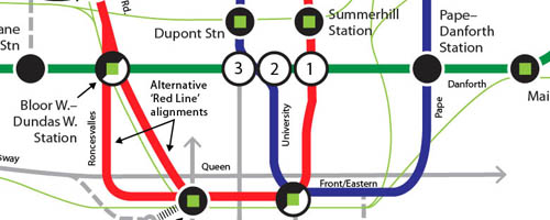
I should explain that I do not consider the terms “system” and “network” synonyms, and I have been careful to avoid using them as such.
Virtually all major cities that have rapid transit enjoy network service, although a few lack certain characteristics. Toronto, however, has a system, not a network: Bloor/Yonge station is the key interchange between the two most heavily used lines, and as such is a point of particular vulnerability in terms of service disruption on the entire system.
A true network, as opposed to the existing skeletal system, would provide more well‐distributed interchange opportunities, and sufficient capacity to handle future travel demand in several currently underserved key corridors across the City of Toronto and the Greater Toronto Area. The current practice of providing inadequate numbers of “replacement buses” during line closures leads to operational chaos as well as rider (and staff) frustration. This situation can only worsen as the more heavily built‐up parts of the urban area (particularly the historic centre) continue to diversify and add population and jobs.
The evolution of a network would involve supplementing existing subway services (essentially the oldest, most underdesigned sections of the system) with strategically planned new lines. Analyses carried out over many decades clearly indicate that the initial additions should include links between the Financial District and the northeast and northwest districts of the city. The rapidly regenerating districts immediately east and west of the financial district, as well as the burgeoning central waterfront, would also be served by such a “U”‐shaped distributor alignment. In addition to the distributor, an east‐west line in the Eglinton corridor would be an essential northern section of an expanded central area network.
Initially, the new lines (forming a circumferential loop configuration) could take the form of “pre-metro” facilities; i.e., grade-separated lines designed at the outset for LRT (light rapid transit, or enhanced streetcar) operation, served by relatively short platforms, designed for eventual upgrading to accommodate conventional high‐capacity subway service, without the need for wholesale reconstruction or expansion of stations and tunnels.[1]
After much debate by Toronto City Council, it has been decided to make the Eglinton Crosstown line into a light rail transit line rather than a full subway. Unfortunately, the Eglinton line is not being designed as a “pre‐metro” that could be converted later to full subway (heavy rapid transit) operation without having to substantially rebuild the stations, turnouts, pocket (storage) tracks, etc., even though a design that could ultimately handle wider subway rolling stock could be provided at the outset without greatly increasing the capital budget. As things now stand, however, any hope of future conversion would likely be too disruptive and costly to carry out. Many areas along Eglinton Avenue have the potential for intensified redevelopment in conjunction with the construction of the tunnel, and this once‐in‐a‐century opportunity could well be hobbled by inadequate line capacity during its operating life.


It’s common knowledge the city has a monetary road fixing crises
Maybe it’s tome for a road repair only tax?

Recent Comments