When I started work on this history, my intention was straightforward: to create a comprehensive record of Toronto-focused rapid transit planning documents prepared since the vision of a rapid transit network was first articulated more than a century ago. I planned to arrange the major reports, monographs, maps, and articles chronologically and supplement each one with a brief commentary. It was not to be a history complete with secondary sources and a wealth of background detail and context, but a record of primary documents on a common theme, arranged and annotated for the interested reader.
I wanted to demonstrate the astounding volume of analytic work done, and to contrast this output with the relatively meagre achievements to date on (or under) the ground. The idea arose from my own frustration after more than 50 years of professional involvement in advocacy, planning, and design relating to public transit and from the realization that in so many ways, my efforts, and those of many colleagues, have been and continue to be in vain.
My task soon proved to be far more complicated and onerous than I had initially envisaged. What was to be a mere compilation of key documents threatened to become a voluminous historical epic replete with an array of technical visions ranging from the overambitious to the niggardly, mirroring changes in political and fiscal circumstances throughout the period. Moreover, I was finding it increasingly difficult to devise a logical point at which to end the narrative, because new initiatives and variations were continually emerging from the bureaucracy, its advisors, and various interest groups. I also found it difficult to refrain from including my own comments on the merits of the various plans and on the decisions of those who were presented with those plans.
Certain core concepts relating to primary public transit service continually recurred in my research, such as the need for major transit routes to follow the arterial corridors originally created by the rectilinear grid typical of the British survey and land subdivision system dating back to 18th-century Upper Canada. This system in turn dictated the form and growth pattern of the future urban area, and in so doing also dictated the configuration of primary public transit services. The relationships between planning and infrastructure made sense before the era of underground railways, when all communal transportation services were necessarily confined to public road rights-of-way (with the exception of railways).
When the idea of subways emerged in Toronto early in the 20th century, the decision to keep the underground lines as shallow as possible to avoid the cost of deep tunnelling and deep stations (and thereby minimize overall trip duration) essentially meant that the lines would either follow or closely parallel the arterial corridors of the primary grid, such as Yonge Street and the Bloor-Danforth corridor. [1]
In the end, I found that the basic characteristics of the rapid transit system were established and later confirmed and refined by way of a relatively small number of key planning initiatives. Indeed, I have concluded that there were only four breakthroughs in the history of general and transportation planning for Toronto and its region:
- Initial concepts for the primary north-south corridor (Yonge-Bay) as well as important east-west corridors (King, Queen, Bloor-Danforth) during the period 1909–1915.
- The series of studies undertaken for the Province of Ontario relating to the Metropolitan Toronto Planning Area and neighbouring counties (prior to the formation of the Regional Municipalities) known as the Metropolitan Toronto and Region Transportation Study (MTARTS) during the period 1962–1968.
- The monumental series of study reports constituting the Metropolitan Toronto Transportation Plan Review (MTTPR) issued during the period 1973–1975. Among the topics documented was the importance of expanding the rapid transit system into anetwork serving the city’s central area with lines oriented in all cardinal directions, including an early concept for the Downtown Relief Line or downtown “U”-shaped distributor; and an east-west line serving the burgeoning upper-midtown districts of Metropolitan Toronto following the Eglinton arterial corridor.
- The profusely documented Regional Transportation Study (“The Big Move”) produced by Metrolinx (initially the Greater Toronto Area/Hamilton Transportation Authority), for the Province of Ontario, during the period 2007–2008.
All else is really a series of politically constrained “footnotes,” generated by or on behalf of successive municipal government agencies and advisors in almost invariably futile attempts to win sustained fiscal support from senior governments.
In putting this information on the web, I hope to remind decision-makers and others of the many important ideas that have been proposed over the years that are still relevant in 21stcentury Toronto. May good sense leading to firm political and fiscal support ultimately lead to the creation of the transportation network that this fast-growing conurbation so desperately needs.
Edward J. Levy, P.Eng. Toronto, Ontario
February 20, 2013
further info from the site
In summarizing the 100‐year history of rapid transit planning and development in the Toronto area using maps and interpretive text, I will emphasize the recurring concept of an enhanced central area rapid transit network. In doing so, I hope to make the strongest possible case for creating such a network within the City of Toronto.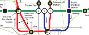
I should explain that I do not consider the terms “system” and “network” synonyms, and I have been careful to avoid using them as such.
- A system is an arrangement of two or more lines that intersect at either a single interchange station (or at two which are very close to one another), resulting in little route redundancy; that is, a means by which riders could follow alternative routes to their destinations to bypass closures caused by service disruptions or emergencies on specific route segments. Rapid transit systems typically offer less‐than‐optimum area coverage and average journey time, and in general, lack operational robustness in terms of service flexibility and balanced demand/capacity relationships.
- A network is an arrangement of two or more lines that meet at two or more spatially well distributed interchange stations, thereby providing route redundancy, resulting in effective passenger load balance on pairs of parallel lines, providing enhanced area coverage and options for bypassing service disruptions. A network is robust in that it allows for not only operational flexibility, but also for growth, change, and progressive land use diversification – all essential for a successful and expanding major urban area such as the Toronto region.
Virtually all major cities that have rapid transit enjoy network service, although a few lack certain characteristics. Toronto, however, has a system, not a network: Bloor/Yonge station is the key interchange between the two most heavily used lines, and as such is a point of particular vulnerability in terms of service disruption on the entire system.
A true network, as opposed to the existing skeletal system, would provide more well‐distributed interchange opportunities, and sufficient capacity to handle future travel demand in several currently underserved key corridors across the City of Toronto and the Greater Toronto Area. The current practice of providing inadequate numbers of “replacement buses” during line closures leads to operational chaos as well as rider (and staff) frustration. This situation can only worsen as the more heavily built‐up parts of the urban area (particularly the historic centre) continue to diversify and add population and jobs.
The evolution of a network would involve supplementing existing subway services (essentially the oldest, most underdesigned sections of the system) with strategically planned new lines. Analyses carried out over many decades clearly indicate that the initial additions should include links between the Financial District and the northeast and northwest districts of the city. The rapidly regenerating districts immediately east and west of the financial district, as well as the burgeoning central waterfront, would also be served by such a “U”‐shaped distributor alignment. In addition to the distributor, an east‐west line in the Eglinton corridor would be an essential northern section of an expanded central area network.
Initially, the new lines (forming a circumferential loop configuration) could take the form of “pre-metro” facilities; i.e., grade-separated lines designed at the outset for LRT (light rapid transit, or enhanced streetcar) operation, served by relatively short platforms, designed for eventual upgrading to accommodate conventional high‐capacity subway service, without the need for wholesale reconstruction or expansion of stations and tunnels.[1]
After much debate by Toronto City Council, it has been decided to make the Eglinton Crosstown line into a light rail transit line rather than a full subway. Unfortunately, the Eglinton line is not being designed as a “pre‐metro” that could be converted later to full subway (heavy rapid transit) operation without having to substantially rebuild the stations, turnouts, pocket (storage) tracks, etc., even though a design that could ultimately handle wider subway rolling stock could be provided at the outset without greatly increasing the capital budget. As things now stand, however, any hope of future conversion would likely be too disruptive and costly to carry out. Many areas along Eglinton Avenue have the potential for intensified redevelopment in conjunction with the construction of the tunnel, and this once‐in‐a‐century opportunity could well be hobbled by inadequate line capacity during its operating life.


Recent Comments